GPS and the 2015 Gorkha Earthquake
Rupture Area Covered by a 5Hz GPS Network for the First Time
尼泊尔容易出现地震,整个世纪以来,该国首都加德满都经常被地震袭击,这些地震似乎具有相似的震中和行为。2015年戈尔卡地震爆裂的主要喜马拉雅势的部分位于GPS连续运行的参考站(CORS)网络下方,记录了三维位置,以每秒5个样本的高速度(5Hz)。这是第一次通过5Hz GPS网络测量了大陆推力地震,在断层破裂的两侧都有接收器。
The various earthquakes which have plagued Nepal over the centuries have caused major destruction, starting in the year 1255 (the earliest one recorded) and subsequently in 1344, 1408, 1681, 1833, 1934 and most recently in April 2015. The latter, the Gorkha quake, had a magnitude of 7.8 and was similar to the 1833 event. The quake in 1934 destroyed 20% of the buildings in Kathmandu and appears to be a repeat of the 1255 one. In comparison, the Gorkha quake destroyed less than 1% of the buildings. Considering the magnitude of the Gorkha quake and its proximity to Kathmandu one would have expected more damage to the vulnerable dwellings, although they are four storeys tall at most. Meanwhile, some high-rise buildings suffered severe damage, such as the 60m tall Dharahara tower which collapsed, despite having partially survived the 1934 earthquake.
CORS GPS网络
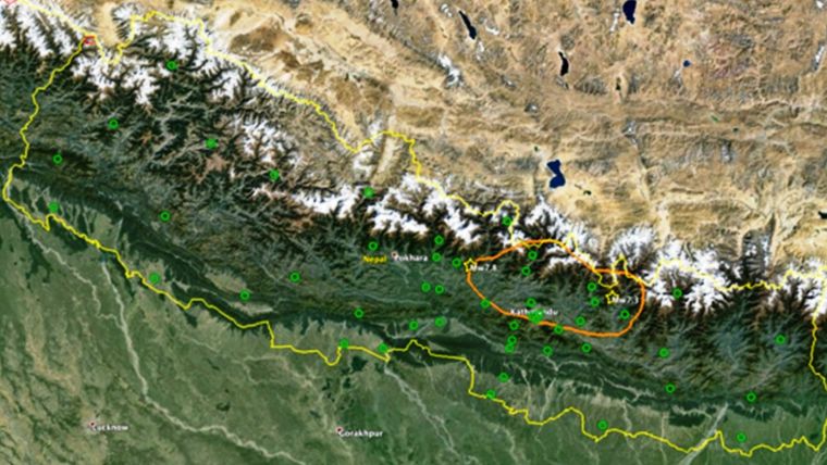
Since the 1990s the California Institute of Technology (Caltech) has partnered with the Nepal Department of Mines and Geology (NDMG) to build a network of 28 GPS stations, consisting of Trimble NetRS, NetR8 and NetR9 reference station receivers. This largest and highest-quality CORS network in Nepal aims at monitoring tectonic strain. In total there are about 50 CORS GPS stations operational, established by several national organisations in close cooperation with various scientific institutions from France, Italy and UAS. Figure 1 shows a map of the GPS CORS network in Nepal based on data provided by UNAVCO, a non-profit university-governed consortium which facilitates geoscience research and education using geodesy. The Caltech GPS receivers capture data at 15-second and 0.2-second (5Hz) intervals. The 15-second intervals provide information on the normal, slow plate motion over several weeks, months and years. The 5Hz data provides details on the shaking during the quake itself. In 2013 the stations were equipped with cellular modems to transmit 15-second GPS data to FTP servers at UNAVCO for long-term monitoring of the plate motion and geophysical research. As the 5Hz data is only needed for examining behaviour and effects when a quake strikes and the volume of data is also too big for the limited bandwidth of cellular connections, the data is stored on the receivers for several weeks. Once a quake happens there should be sufficient time to collect the data by on-site visits. In order to deal with connection failures the receivers can also store 15-second data for up to one year or up to three years, depending on the type of receiver. As the 5Hz data accumulates very rapidly and recent data prevails, older data is overwritten by newer data within several weeks. Therefore, to prevent loss of important data, the data must be downloaded during on-site visits within just a few weeks of an earthquake striking.

Data Rescue
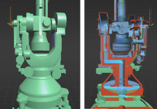
尽管所有这些预防措施,但一旦戈尔卡地震袭来,数据检索就变得不稳定。安装两年后,许多GPS站的无线连接被破坏了。在地震时,只有九个电台可以传输数据,而其他人的状态未知。尽管许多站点失去了连接,但他们继续存储GPS数据。但是,由于滑坡和其他危险,通过现场访问的检索似乎非常麻烦。除此之外,直升机的可用性只有有限的,因为当然,他们迫切需要急需急需的人。通过Trimble的资助,可以在几个小时内聘请直升机,从而占用救援工作。在现场,下载数据,并在可能的情况下修复了连接断裂的接收器。无法弥补的接收者,包括雷击和故意破坏或其他原因损坏的接收者,被新的GNSS接收器取代,并被运送到加德满都以进行数据恢复和维修和重复使用。地震对各个地点造成了不同程度的损害,并在某种程度上殴打了接收器,但尽管某些站位于断层破裂上方,但它并没有使任何一个造成任何能力或损坏任何天线(图2)。 The integrity of the GPS data appeared to be consistently good. Obviously, the short-braced monuments were solid enough to withstand the shock waves.

Results
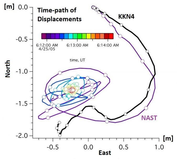
Figure 3, showing the 5Hz GPS measurements at two individual CORS (KKN4 and NAST) during the quake, clearly demonstrates the occurrence of large initial displacements and accelerations associated with the shaking at the strong motion accelerometer KATNP, installed at the American Club operated by the U.S. embassy in Kathmandu. KKN4 is located on rock and NAST on sediment in a valley. The north and east displacements of the two stations clearly show different behaviours (Figure 4). NAST shows prolonged sediment resonance with a sweeping path of almost 2m. The small circles on the KKN4 displacement path indicate one-second intervals; the larger circles on the NAST displacement path indicate intervals of 0.2 seconds. Combining 5Hz GPS data and data captured by KATNP shows that the Kathmandu valley heaved upwards by 60cm and moved southwest by 1.5m at velocities of up to 50cm/s in less than 5 seconds. In the following 60 seconds valley sediments oscillated laterally at 4-second intervals with 20-50cm amplitude. Surfaces horizontal prior to the quake are now tilted down to the southwest by less than 1 degree. The runway at Kathmandu’s airport lifted roughly 50cm and tilted by 12cm. The shaking in Kathmandu was not as violent and severe as one would expect based on the large amount of strain released. More work is needed to understand whether the Gorkha quake put additional stress on other faults in the area, which could influence occurrence of future earthquakes. Surface displacements were also measured with interferometric synthetic aperture radar (InSAR). The combination of all these measurements enables visualisation of the kinematics of the sources and the strong ground motion that led to the pattern of damage.

GNSS Receivers
Nepal’s GPS network continues to monitor tectonic motion. Because the GPS equipment at the existing stations was largely undamaged, many of the receivers donated by Trimble for replacing incapacitated receivers were instead used to establish new stations. Since those receivers are GNSS-capable, they capture not only GPS signals but also signals from GLONASS, Galileo and BeiDou. This extension of the amount of signals allows placement of receivers in deep valleys where they are easily accessible. Seismic sensors are installed at many CORS sites.
总结说
地震发生在定期时间间隔中,但这并不意味着即使使用最先进的仪器和技术,也可以准确预测它们的袭击。但是,现代测量技术使人们能够理解地震和GPS数据的模式,使沿板边界积累的构造应变建模以及对即将到来的地震强度的估计。除此之外,在戈尔卡地震期间进行的测量值可以改善施工,以减轻未来的损害和生命损失。
Further Reading
Avouac,J-P。,Meng,L.,Wei,S.,Wang,T.,Ampuero,J-P(2015)锁定的主要喜马拉雅锁的下边缘,被2015年Gorkha地震解压缩,Nature Geoscience8,708–711。
Avouac, J-P, Melgar, D., Bock, Y., et al. (2015) Slip pulse and resonance of Kathmandu basin during the 2015 Mw 7.8 Gorkha earthquake, Nepal imaged with geodesy,ScienceXpress, sciencemag.org/content/early/recent / 6 August 2015.
致谢
感谢科罗拉多大学的约翰·加雷茨卡(John Galetzka)和科罗拉多大学的罗杰·比勒姆(Roger Bilham)提供了背景信息。
使您的收件箱更有趣。Add some geo.
Keep abreast of news, developments and technological advancement in the geomatics industry.
免费注册