Lidar Scanning by Helicopter in the USA
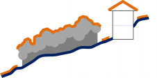
Capturing Levees, Riparian Boundaries and Railways
近年来,使用无人机的空中系统(UASS)被飙升为通过图像和激光雷达捕获地理数据的手段。然而,这并不意味着经过验证的平台,例如直升机,已经过时了。对于各种应用,LIDAR扫描来自载人的斩波者是多才多艺的,快速,经济效益和没有法律的障碍。在本文中,作者详细阐述了堤坝,河岸边界和铁路3D建模的有效性。
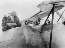
Choppers are used ubiquitously to monitor rush-hour traffic and for search and rescue operations. Equipped with Lidar for collecting point clouds, they outperform mobile mapping by car and UAS in various settings. Choppers can access areas which cars cannot. Heavy winds and severe weather prevent most UASs from taking flight, as can legal restrictions. Helicopters can be flown legally anywhere in the USA, enjoy a wide community of pilots, and are quite affordable. Compared to a light fixed-wing aircraft they are more economical plus they can hover over an area of interest and capture data from different angles, which for a fixed-wing is almost impossible due to the fixed, directional flight path. Table 1 shows the main features of the Robinson R44 and MD 500 choppers used by the authors for Lidar geodata acquisition.
Robinson R44 |
MD 500 |
|
最大限度。有效载荷[kg] |
340 |
664. |
最大限度。stay in air [h] |
> 3 |
> 3 |
最大限度。速度[km / h] |
200 |
282. |
最大限度。height above ground [m] |
4300 |
4875. |
推进 |
GAS 100LL |
GAS 100LL |
转子直径[m] |
10.1 |
8.03 |
Height |
3.3 |
2.48 |
表1,主要直升机功能。
Lidar systems
Lidar is used to detect and measure the distances to surfaces by means of laser beams. Most airborne Lidar sensors use single beam to bridge the ranges from the aircraft flying at high altitude and the terrain. While the data yielded by these systems is quite good, the expense can be prohibitive. For mobile mapping威达尔提供两个360度扫描系统:HDL-32E为32个光束/通道,每秒700,000点,更新,较小的VLP-16 LIDAR PACK,具有16个光束/频道,每秒300,000点。激光器在其他主要特征方面类似:波长为905nm,脉冲长度小于10ns,记录每个脉冲的两个回波,最大范围为75米,并且返回的强度被记录为8位。两者都使用NovaTel Stim作为GNSS / INS系统,APM作为任务规划软件和Scanlook作为后处理软件。
Levees
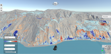
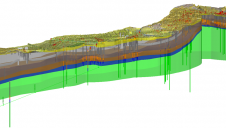
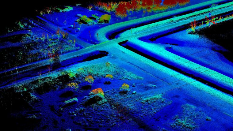
Levees are captured with either airborne Lidar or by ground survey. Aerial mapping enables large areas to be captured in one go but the level of detail may be too low. Ground surveys involve much equipment and personnel who may be confronted with unstable terrain and other dangers as well as obstacles like fences and walls. Although time-intensive, the measurements are very accurate at the few points where data is collected. However, there may be a need to revisit areas where no data was captured. During two days, two crews surveyed just 1.5km of the winding levee which has a length of 24km. Mounting the ScanLook Snoopy took under 30 minutes with nothing more than a screwdriver – specialised clamps similar to a vice grip could reduce the time needed. The levees were captured at a speed of 30 to 80km/h with up to 90-degree turns and vertical movements to avoid collision with tall utility structures. Capturing at low water level ensured coverage of the actual water basin, but there was still considerable vegetation with tall grass and brush. Cross-sections and points on roadways and bridges were used as ground control points (GCPs). The nature of laser spread allowed the capture of abundant points to create a bare-earth digital elevation model (DEM) with a height accuracy of a few centimetres, which was used in a hydraulic study.
Riparian boundaries
在沼泽和低地和沿河,湖泊和其他水体中,房地产界限通常由轮廓线定义。轮廓线的本地化是维护海岸线的必要条件,以便提供对其他方面的公众访问区域,无法通过抵押或危及普通公众来识别邻近所有者的可能侵占。这些环境通常对人体通道具有敌对。使用沼泽网格或船只,或徒步,是侵入性的,它需要数周,因此昂贵。Scanlook Snoopy安装在Robinson R44上,捕获了3 x 2.7km的面积2浅水沿着平行线散布着陆地群体,具有50%重叠。在60米的高度,速度为55到65公里/小时,该区域覆盖一小时。GCPS在该地区周围的硬表面上使用,沿着可散步的小径。法律轮廓线是从裸土的DEM生成的。
铁路
铁路线和方式的权利通常是从铁路马车或Hyrail(混合型车/铁路货车)扫描的。铁路旅行受到严格的政府安全法规的约束,妨碍了流畅的工作流程;捕获几公里可能需要数小时。从空中扫描避免了这样的封闭,并使围栏,建筑物和其他困难区域后的沟渠和区域捕获。可以容易地预测调查的持续时间,因为它由铁路线的长度,直升机的条带数和速度的长度决定。
杰夫法珀兰, PLS, has a surveying degree and a graduate degree in photogrammetry. After leaving Intergraph in 1999 he founded LIDARUSA (Fagerman Technologies) in Somerville, Alabama, USA. He is CEO and owner.
Wolfgang Juchmannearned his PhD in laser spectroscopy of combustion flames and thin-film deposition plasmas from the University of Heidelberg, Germany. He is director of sales & marketing for Velodyne’s Lidar Division in Morgan Hill, California, USA.
Make your inbox more interesting.Add some geo.
Keep abreast of news, developments and technological advancement in the geomatics industry.
Sign up for free