喀麦隆的移动道路映射
支持水公用事业更新
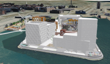
在Yaoundé,喀麦隆,公共资产和公用事业的一点发言人数据。为了有效地翻新城市的饮用水网络,使用移动制图技术,采取额外的注意,确保赤道附近的平面精度。它为项目规划所需的路线图提供了GIS数据。实验方法 - 用全部阶段的网络建设项目集成的GIS和网套 - 与当前的非洲背景有良好契合,并为未来项目提供了有希望的潜力。
喀麦隆水公用事业公司和水喀麦隆共同负责创造和翻新基础设施,为喀麦隆人口提供饮用水。虽然这个西非国家的局势正在改善,但在首都雅育,例如,人口为2,500万 - 仍然只有少数群体通过个人联系获得饮用水。yaoundé的饮用水基础设施的翻新是必要的;必须建立一个新的地下水网络。但该工作的建筑公司分包 - razel bec fayat - 确认其实施计划的准确路线图,他们无法获得。
紧迫的期限和缺少最新的调查和GIS.data about Yaoundé led Razel to choose a mobile mapping system (MMS) for city surveying purposes. The mobile collection of georeferenced images would enable a fast and effective field survey. The surveys had to be performed as quickly as possible, since 230 kilometres of urban roads needed to be covered before the start of the rainy season.
Field data collection
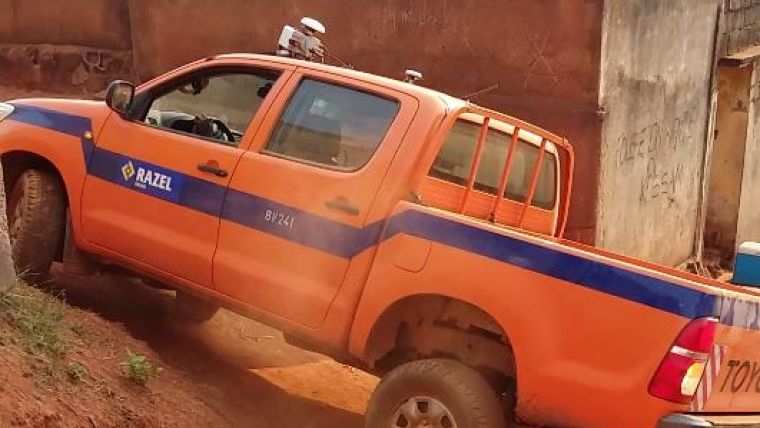
The company Immergis was asked to help manage this mapping amd GIS project, and the Imajbox MMS (by the French company Imajing) was chosen as the equipment to be used. Imajbox could be easily mounted on any vehicle suitable for the challenging local road conditions. A large part of the city’s road network is neither paved nor maintained, which makes access and surveying difficult. The mobile collection of georeferenced images proved to facilitate field surveying in record time. The surveys were optimised by using two synchronised systems oriented towards two different angles. Each road was covered in both directions. Field operation teams had to deal with unforeseen events. Confronted with traffic jams and busy streets crowded with markets and small businesses, the teams adapted their surveying times to early morning and non-working days. The MMS enabled quick installation and automated calibration at any time. The Yaoundé survey took just eight days, so work was completed before the rainy season.
Improving the GNSS signal
In areas close to the equator, like Cameroon, global navigation satellite system (GNSS) signals are affected by strong atmospheric influences such as ionospheric errors. Consequently, GNSS-based survey results often are not as good as in mid-latitude areas, such as in Europe. Hence, GIS data cannot be extracted for road map creation without extra steps to improve the absolute planimetric accuracy. In Yaoundé, no RTK infrastructure with ground reference base station network was available. Therefore, the project team decided to use an additional external receiver, synchronised in time with the Imajbox system, to receive real-time geostationary satellite constellation corrections. In post-processing, the results calculated by the receiver and inertial data from the MMS were merged to enable geographical positioning of each image surveyed. This configuration made it possible to collect GIS data with sufficient accuracy for road map design.
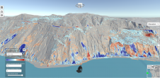
Map production
DWG maps with detailed roads and asset locations, positions and dimensions were required for end usage in CAD software. Other elements of the Imajing software suite were used to extract GIS data from the survey results and also to make 3D measurements in images. Points and lines were produced to identify road shoulders, roadside slopes and all urban assets and road environments. A GIS database was built. The insufficient number of geodetic markers located within the city boundaries proved to be challenging. It is difficult to unify data – especially the altimetry data – derived from modern technologies and traditional levelling methods that were used in Cameroon. Existing geodetic markers combined with local cadastral data were used to recalibrate the survey data and provide reliable Z coordinates. The database was smoothed and readjusted based on the different sources of information available. Within three months, Immergis had produced the road maps and provided DWG maps each week. This enabled constructor Razel to perform all the pre-work planning before making a start on the new water network. Furthermore, the usage of the mobile mapping technology aroused the interest of other companies in road construction and linear infrastructure projects. They all require up-to-date spatial data, and this project demonstrated that acquisition can be quick, efficient and reliable.
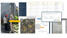
工作规划和监督
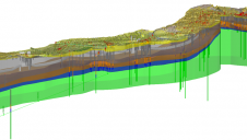
To display road maps, the location of project water pipes and survey images, the Immergis Web GIS platform was used. It helped the project team during work planning, reduced the number of field visits and accelerated the production of execution drawings. But planning and implementing construction works for 230km of underground water pipes in less than two years in a city like Yaoundé is a sizable challenge. The project manager at engineering company Razel needed the GIS to go further; it had to become part of the everyday life of the project at all stages. He requested that the GIS should assist with the work supervision, ease day-to-day decision-making and speed up the production of hundreds of mails to be sent to the project partners, such as the city council and the existing telecom, water and electricity network operators. Adapting the software to the project needs and to the local context, such as fluctuating internet access, was also challenging, but Immergis Web was successfully adapted to include a document management system, allowing the automatic generation of the mails (such as works authorisations or network cuts) that needed to be sent in each project phase. Other functionalities such as real-time display of the progress at each worksite were also developed.
The successful implementation of GIS software and web suites in this project has made the engineering company rethink and adapt its work procedures in order to integrate the approach into its internal processes. 25 project members at Razel, ranging from engineers and quality, safety and environment managers (QSEs) to project managers and designers, are now using the platform on a daily basis.
Authors
Sébastien Albouy是莱茵河·帕梅隆的液压主任,喀麦隆和雅温得供水改善项目的项目负责人。他在世界各地拥有20年的建筑公司和供水工程经验。188asia备用网址
Vincent Lecamusco-founded Immergis and has been CEO for the past 11 years. He is an expert in mobile mapping services for network and assets management.
InèsGuth.is marketing and business developer at Imajing s.a.s. and is involved in several international projects.
Acknowledgements
Thanks go to Julien Cour, project manager for Immergis Africa, Manon Justal, business developer for Immergis, and Etienne Lamort de Gail, CEO of Imajing, who provided additional information for this article.
让你的收件箱更有趣。Add some geo.
Keep abreast of news, developments and technological advancement in the geomatics industry.
免费注册