Plymouth Prepares City for Emergencies with GGP's Mapping Technology
Plymouth is using the latest mapping technology to prepare the city for major emergencies. Plymouth City Council is using a Geographic Information System (GIS) from GGP Systems to help produce emergency planning maps. The Council’s Civil Protection Unit has created the mapping for a range of exercises relating to a major incident in the city such as flooding, terrorist attacks or even a nuclear accident. Prepared for use in the event of a real-life scenario, the maps are, however, vital for staff training and inter-agency coordination, and have supported the launch of a new warn and inform service for residents and businesses close to locations identified as possible high-risk sites.
“Although uncommon, major emergencies are inevitable fact of life. They can manifest themselves in many forms ranging from natural disasters, such as severe weather or flooding, to man-made incidents associated with commercial or industrial activity and even acts of terrorism and war,” said Scott Senior, Civil Protection Manager within the Civil Protection Unit of Plymouth City Council. “As a Unitary Authority with statutory emergency planning and community resilience responsibilities, we must respond in a rapid, effective, efficient and coordinated manner, whatever the emergency may be.
“To achieve this it is essential that we not only plan for all eventualities but also undertake staff training and devise and run exercises designed to both reinforce this training and validate agreed procedures. The maps produced in GGP GIS are critical, not only in the planning of emergency responses but also in the training of staff and the coordination of agencies in both desktop and live exercises, as well as actually in an emergency, as defined in the Civil Contingencies Act 2004.”
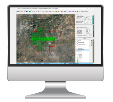
The primary function of GGP GIS within the Civil Protection Unit is to map public information zones around sites where a major incident could occur. These sites currently include oil terminals, fuel distribution centres, munitions stores as well as the Devonport Dockyard, which berths and refuels nuclear-powered submarines. The sites are analysed in GGP GIS and, using the Council’s centralised address database (Local Land and Property Gazetteer), individual properties that may be affected are identified. In the case of an incident these addresses will be issued with relevant information and will be the addresses the Council evacuates should the need occur.
GGP GIS也用于实时练习,例如来自城市的德文波特船坞的放射性泄漏的多机构场景,代码为短讲道。“通过绘制这种事件的确切影响领域,我们可以快速识别受影响的财产,并将这些信息与其他当局或机构出口,以与普利茅斯主要事件的紧急响应相关的其他当局或机构分享,”斯科特的高级结束了。“在现实生活场景中,该信息对于管理碘化钾的分布至关重要(可以帮助阻止放射性碘从甲状腺吸收的稳定碘的盐)到受影响的特性。”
让你的收件箱更有趣。Add some geo.
Keep abreast of news, developments and technological advancement in the geomatics industry.
免费注册