Leica Reveal iCON Construction Total Stations
Leica Geosystems, an industry leader of measurement technology, has announced the Leica iCON construction total stations, Leica iCR70 and Leica iCR80, the most productive one-person layout solution fo...
Indoor mapping is a novel concept that uses a digital 2D or 3D map to represent an indoor venue and spatial information. Indoor positioning and navigation are made possible by presenting places, people, and assets on a digital map. As a result, many various use cases are possible, allowing businesses to improve their workflows and efficiency.

Leica Geosystems, an industry leader of measurement technology, has announced the Leica iCON construction total stations, Leica iCR70 and Leica iCR80, the most productive one-person layout solution fo...

As part of the Prime Minister’s London Tech Week roundtable, the Government has announced that key parts of the OS MasterMap will be made openly available for the public and businesses to use in the...

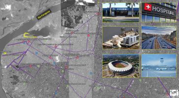
Esri, the global leader in spatial analytics, and DigitalGlobe have announced they have created a Story Map of high-resolution imagery that visualises the 12 venues being used for FIFA World Cup 201...

The Open Geospatial Consortium (OGC) has released a Call for Participation to solicit proposals for the OGC Indoor Mapping and Navigation Pilot initiative. The Indoor Mapping and Navigation Pilot, spo...

Mansfield District Council has undertaken a project to replace their outdated GIS and reduce desktop GIS licensing costs. The council’s GIS team was looking for an intuitive, internet based GIS wher...

六角AB,全球领先的数字解决方案,has introduced another industry-first solution in its popular BLK line – the Leica BLK3D – a compact 3D handheld imager that improves productivity...

Theatrework UK, a Scottish production company, is using laser scanners and 3D computer modelling technology to help visualise stage productions. Using Pointfuse software, laser scanned data – point ...

A new report by Global Market Insights has projected the market for aerial imaging services to be worth US$4 billion by 2024, with UAVs primarily driving the anticipated growth. The report characteris...

DroneDeploy, a drone software company with the largest drone data platform in the world, has announced the launch of Thermal Live Map, a real-time mobile mapping solution which delivers insights only ...
ImageSat International N.V., a global leader in end-to-end geospatial solutions, together with MAGNUS International Search & Rescue has announced a new service - Emergency and Disaster Management. Th...
This site uses cookies. By continuing to use this website, you agree to ourCookies Policy.Agree